
.
.
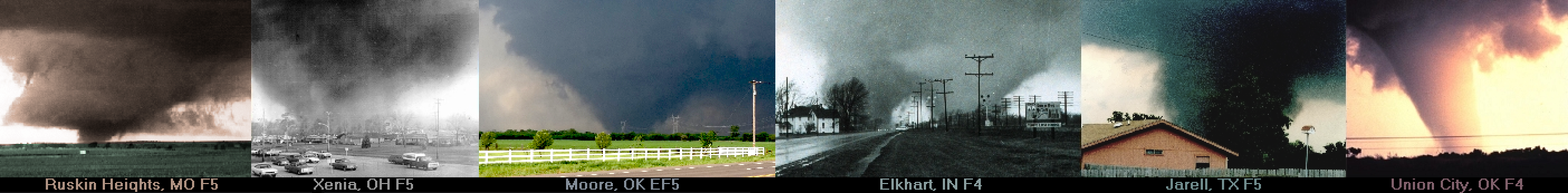
On the EF-scale, the distribution of tornado processes is broad at the low-end and narrow at the high-end. Weak tornadoes, which include most tornadoes, form in a multitude of ways involving a wide range of storm types. 1 As EF-scale increases, storm types become increasingly organized and the process in which tornadoes form looks more and more similar. Violent tornadoes require extremely well-organized storms. For high-end destructive tornadoes, one process is dominant, but there is still some variance within this process. We will first look at the process for violent tornadoes.
.
.
A supercell thunderstorm is necessary for a violent tornado (EF4 to EF5). Supercell thunderstorms develop when instability, moisture, lift and vertical shear are sufficient to produce vigorous updrafts that are organized and persistent. 2 For these storms to persist, the updraft must not be suffocated by the downdraft. Vertical shear tilts the updraft away from the downdraft allowing for a self-sustained thunderstorm. Vertical shear also creates horizontal vorticity that is ingested into the storm. When this horizontal vorticity is turned vertically into the updraft, the storm will begin to rotate. 3 4 5 As this occurs, a supercell can develop and persist for an extended period of time. Supercells are the general requirement for violent tornadoes.
.
.
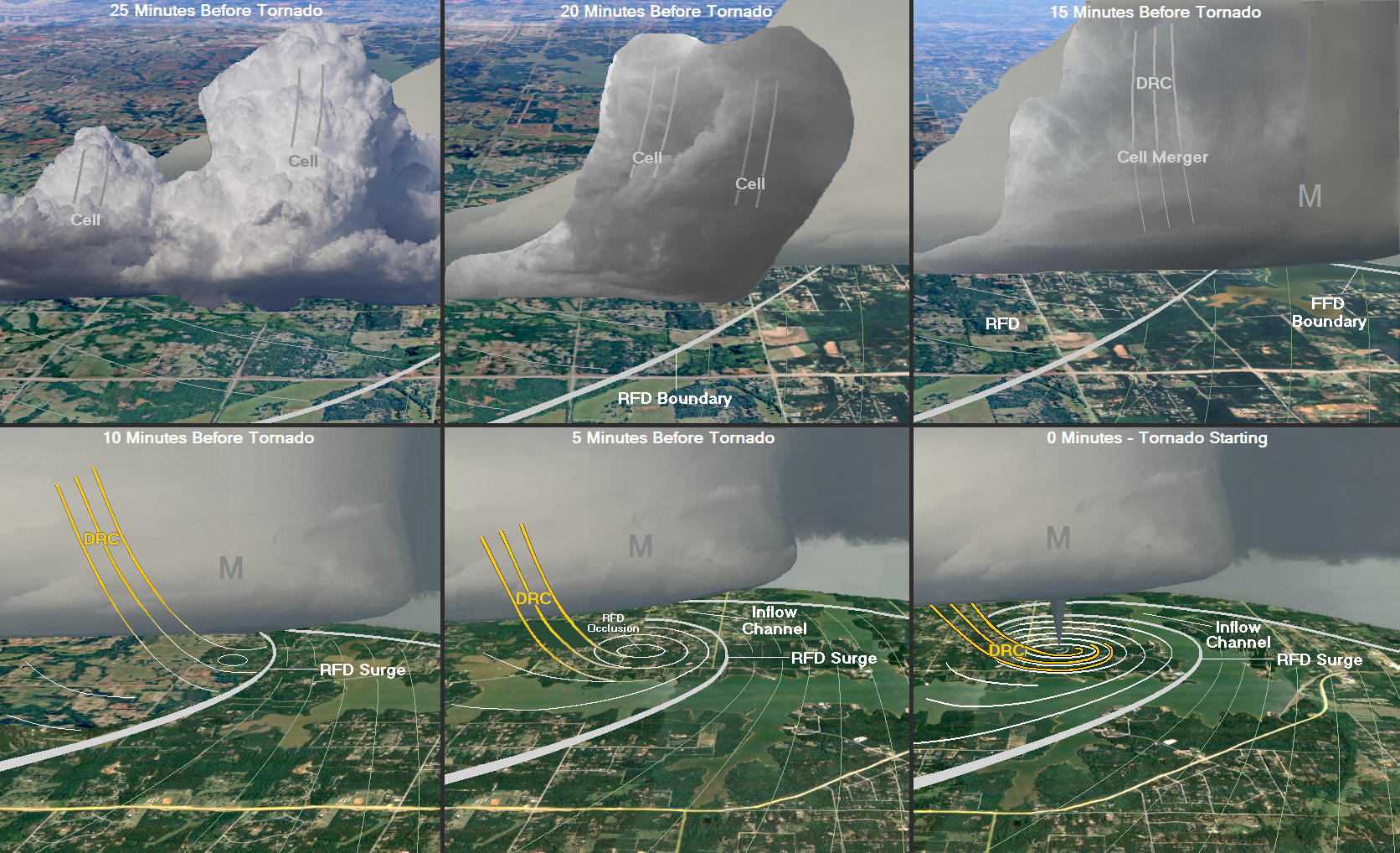
Over the last seveny-five years, the process of tornadogenesis has been gradually revealed. Recently, more detail has been discovered on how this process occurs for high-end supercells that produce violent tornadoes. That process is described here. First, a strong mesocyclone develops within the supercell’s updraft. 6 7 Violent tornadoes require a strong mesocyclone. Initially, the mesocyclone is located over or near the inflow sector of the supercell, where instability and low-level shear are maximized. This location is favorable to help the meso reach an extreme intensity, but also means the meso is inflow dominant. Low-level rotation in an inflow-dominated meso is lifted upward away from the ground making it difficult for a tornado to be produced. The meso needs to become close to the downdraft of the supercell so that high winds and rotation can be dragged down from the meso to the ground. This is accomplished by a surge of the rear flank downdraft (RFD). 8 9 It is important to note that the downdraft in the RFD is visible when the number of hydrometers is sufficient, but at other times the RFD can be hard to visually observe. Sometimes the RFD can undercut a cloud base, being present in the lowest few hundred meters but not affecting the cloud itself. When this happens, the RFD and its internal features can be an instigator of tornadogenesis with practically no visual evidence. That is why it is important to analyze radar before making a conclusion about whether an RFD is present or not. In most cases, the rear flank downdraft is located on the southwest side of the supercell, where a pool of outflow becomes somewhat steady-state. This pool of outflow needs to be unstable so that the mesocyclone does not weaken during the RFD surge. 10 Just after the RFD surge starts, a descending reflectivity core (DRC) will be produced. 11 12 13 The RFD surge will also create an inflow channel. The DRC and inflow channel will set the stage for violent tornado development. 14
.

.
Supercell Schematics

Fujita 1975
.
.
On the tornadic supercell schematic above from Ted Fujita, the position has been marked of the rear flank downdraft (gold), the descending reflectivity core (red) and inflow channel (blue). His graphic was the first to show these last two features, even though the terms had not yet been coined. His graphic is considered by many to be the most detailed and accurate supercell schematic ever made. The supercell schematic (below) also shows several of the same features but at the violent tornado stage, with a description of high-end tornadogenesis at the bottom. You can download and save the image (violent tornadic supercell schematic).
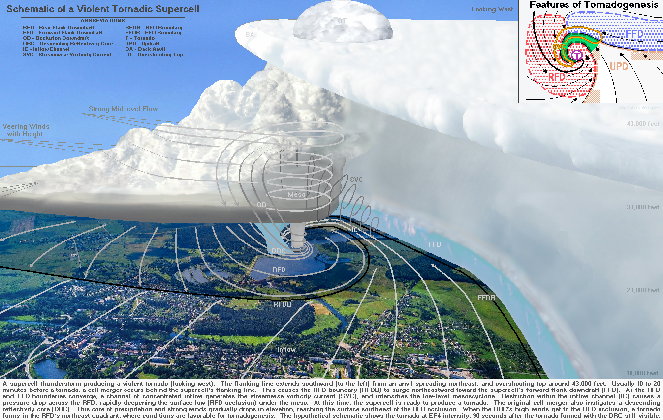
Broyles 2022
The Process For Violent Tornadoes
.
Cell mergers appear to be important to high-end tornadogenesis. 15 16 On average about a half hour before the violent tornado, one or two cells will initiate somewhere in the potentially tornadic supercell’s rear flank downdraft. 17 The development of these cells can be triggered by a nudger, which can consist of a storm that approaches the supercell but does not merge with the supercell itself. 18 These cells can also be triggered by approaching outflow, by convergence along the RFD boundary, or on more rare occasions, can develop within the flanking line itself. Cells that initiate externally from the supercell will gradually move toward the supercell’s flanking line. If two cells are present, then these two will often merge before reaching the flanking line. If one cell is present, then the merger will take place with the flanking line itself. On average, these cells will merge about 15 minutes before the violent tornado starts. The cell merger is usually most evident aloft, most commonly between 10,000 and 20,000 feet (3,000 to 6,000 meters), but in some cases can happen above or below this range. From this cell merger, an RFD surge is produced, along with a descending reflectivity core (DRC). The DRC forms as the downdrafts from the merger combine into a stronger and more densely concentrated downdraft. As the cells merge, the weaker downdraft core in the merger gets pushed downward by the stronger downdraft. The stronger downdraft then follows and the combined core descends towards the ground, reaching the surface just before the tornado begins. Early in the process, the DRC allows for the entrainment of strong mid-level flow aloft. This enables the DRC to pull down high winds from above. As the DRC approaches the ground, the dense core acts as a mechanism to block low-level flow. 19
.References
When the RFD surges, the RFD boundary will move northeastward toward the supercell’s forward flank boundary. 20 Inflow will be forced to rise over the leading edge of the RFD. As the RFD pushes beneath the low-level meso, air from the supercell’s inflow sector is cut off from entering the base of the meso. When this happens, vertical shear is reduced under the meso and the environment becomes more favorable for the alignment and persistence of vertical vorticity, especially near the ground. The RFD surge creates a narrow corridor in which inflow must navigate on its way to the mesocyclone. 21 This narrow corridor is called the inflow channel. When an inflow channel is created, the amount of air entering the base of the mesocyclone decreases. As the meso continues to evacuate air aloft at a similar rate, the reduced amount of air entering its base causes a pressure deficit at the surface. As the pressure drops beneath the meso, an RFD occlusion develops in the form of a deepening surface low across the RFD. The violent tornado will develop in the center of the RFD occlusion. 22
.
From five to ten minutes before the violent tornado, the RFD occlusion deepens as random vorticity patches form and move around the surface low. From zero to four minutes before the tornado, the DRC reaches the ground to the west-southwest of the RFD occlusion. At this time, surface rotation markedly increases with a more concentrated zone of vorticity generation developing along the inside edge of the DRC. This is what is called the vorticity feeder, which Ted Fujita first described in the mid 1970s, after he examined the damage produced by violent tornadoes in the historic April 3-4, 1974 Super Outbreak. 23 With some violent tornadoes, damage from the DRC can be seen starting to the west-southwest of the tornado damage, along with evidence of the vorticity feeder. This feature is located along the northern edge of the DRC, where a localized pressure drop occurs on the side closest to the meso. The DRC helps to keep the developing axis of vertical vorticity aligned with the low-level meso, 24 and acts as a blocking mechanism to protect the vortex from being torn apart by low-level shear. As the nose of the DRC wraps around the RFD occlusion, it acts like a wall with a vertically oriented curl of rotation developing on its lee side. The tornado forms as vorticity is amplified within this curl of rotation, 25 with the column of vorticity developing upward very quickly starting near the ground. 26 During the few minutes leading up to the tornado, the inflow channel gradually moves around the north and west side of the RFD. An inflow channel connection is often made just as the tornado is starting. The inflow channel provides the new tornado with an ideal source of moisture and instability, and supports the tornado as it intensifies, eventually into a violent vortex.
.
.
High-end Tornadogenesis
.
Broyles 2025
High-end tornadogenesis involves a cell merger, which instigates an RFD surge and a DRC. As the RFD boundary surges toward the forward flank, an inflow channel is created. Inflow is forced through a narrow corridor, which reduces the amount of air flowing into the base of the mesocyclone. A pressure deficit develops beneath the meso as air is evacuated upward at a faster rate than is replaced below. In response, a surface low forms and deepens across the RFD. This RFD occlusion strengthens as the DRC approaches from the west-southwest. The DRC acts as a blocking mechanism, which accelerates the pressure drop at the center of rotation. The tornado forms shortly after the DRC reaches the surface, as the nose of the DRC wraps around the RFD occlusion. 27
.
Descending Reflectivity Core (DRC)
.
 Fujita 1978 | 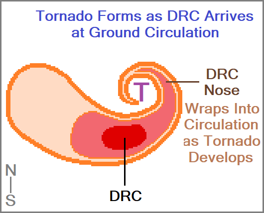 Broyles 2022 |
At left, the position of the DRC and DRC’s nose have been marked relative to the vorticity feeder on a graphic by Ted Fujita in 1978. 28 Without seeing Fujita’s schematic, a nearly identical DRC structure is show at right from a study in 2022. 29 The two graphics were drawn 44 years apart, and are in remarkable agreement.
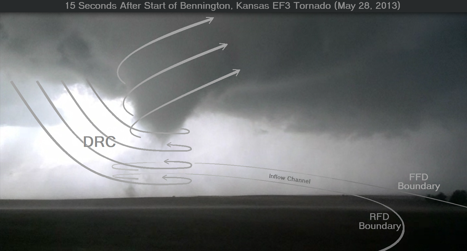
Jeremy Diehl 2013
This photo was taken on May 28, 2013 by Jeremy Diehl about 15 seconds after the Bennington, Kansas tornado began. It was annotated in 2023 by the website’s author to show the estimated positions of the RFD boundary, FFD boundary, DRC and inflow channel.
Strong Tornadoes
.
Strong tornadoes (EF2 to EF3) develop in a variety of ways compared to violent tornadoes. The first way involves the same process as for violent tornadoes, except that the process described above is short-circuited in some way or another. When this happens, often the culprit is an inflow channel that is never able to make a connection to the tornado. In this case, the tornado draws in less unstable air from the RFD, making the environment unfavorable for high-end tornadogenesis. A limitation for tornado intensity can also happen if the RFD surge remains under-developed. This problem is often amplified in low-precipitation (LP) supercells, which rarely produce strong tornadoes. 30 Another limitation for tornado intensity in a supercell is a weak meso. 31 In this case, a nudger may help a less-organized supercell produce a strong tornado, because of increased rotation associated with the cell interaction. 32
.
In addition, the location of tornado development within a supercell may become a negative factor, reducing the maximum strength of the tornado. For example, a tornado may form near the RFD boundary of a supercell by either narrow streams of upward-turned horizontal vorticity, 33 or by vertical vorticity that is created by low-level convergence along the RFD boundary itself. Although rare, strong tornadoes can also form along the northern edge of the inflow channel near the forward flank boundary, where the southern edge of the streamwise vorticity current (SVC) exists. 34 35 These satellite tornadoes move cyclonically around the north and west side of the RFD and may eventually merge with a large RFD-related tornado at the center of the mesocyclone.
.
Strong tornadoes can also form within the RFDs of relatively small supercells, associated with the inner and outer bands of hurricanes. 36 These supercells usually lack organization due to either weak instability, marginal deep-layer shear or limited large-scale ascent. Additionally, strong tornadoes may also develop within the rotating head of a bow echo. 37 38 39 This feature is a storm-scale rotation that can persist, with inflow that originates from the rear of the storm. Strong tornadoes can also develop along the leading edge of a quasi-linear convective system (QLCS). 40 When a QLCS or short line develops a bowing structure, vorticity can become enhanced along the leading edge of the bow, producing a tornado just to the north of the bow’s apex. 41 42 Tornadoes associated with book-end vorticies are also possible near the north and south end of the bowing line segment. 43 In these situations, vorticity is enhanced by convergence, and upward vertical stretching can increase tornado intensity into the strong category. 44 These types of tornadoes have vorticity that is focused near the ground, which makes them short-lived.
.
.

Fujita 1978
.
Weak Tornadoes
.
Weak tornadoes (EF0 to EF1) can involve any of the methods discussed above when these processes short circuit. 45 Weak tornadoes are quite common near and around supercell mesoyclones, and along the supercell’s own boundaries. Weak tornado-producing supercells are often considerably less organized, and can sometimes either involve low precipitation (LP) 46 or heavy precipitation (HP) storms. 47 In other scenarios involving non-supercell thunderstorms, weak tornadogenesis is preferred along boundaries, such as cold fronts, warm fronts or outflow boundaries. 48 49 Tornado formation can take place near the boundary when convergence is maximized underneath a developing storm. These tornadoes form as rotation is stretched vertically into a strong updraft. 50 The stretching of vorticity can result in a small tube-like spinnup. These short-lived tornadoes often take the form of a landspout, with the connecting cloud remaining small and weak. 51 52
References
American Society of Civil Engineers (ASCE), 2006: A Recommendation for an Enhanced Fujita Scale. Texas Tech University, 95 pp.
Atkins, N. T., J. M. Arnott, R. W. Przybylinski, R. A. Wolf, and B. D. Ketcham, 2004: Vortex Structure and Evolution within Bow Echoes. Part I: Radar and Storm Damage Analysis. Mon. Wea. Rev., 132, 2224–2252.
Bluestein, H. B., 1985: The formation of a “landspout” in a “broken-line” squall line in Oklahoma. Preprints, 14th Conf. on Severe Local Storms, Indianapolis, IN, Amer. Meteor. Soc., 267–270.
Bluestein, H. B., and C. R. Parks, 1983: A synoptic and photographic climatology of low-precipitation severe thunderstorms in the Southern Plains. Mon. Wea. Rev., 111, 2034–2046.
Brooks, H. E., 1949: The tornado cyclone. Preprints, First Conf. on Severe Local Storms, Amer. Meteor. Soc., Kansas City, MO, 10 pp.
Broyles, J. C., C. K. Potvin, G. L. Dial, J. Murnan, S. Shores, A. D. Lyons, M. S. Elliott, and A. R. Cook, 2022: Tornadogenesis in high-end tornadic supercells, Part 1: The RFD surge, RFD occlusion and cell mergers. 30th Conf. on Severe Local Storms, Santa Fe, NM, P13-18.
Broyles, J.C., C.K. Potvin, G.L. Dial, J. Murnan, S. Shores, A.D. Lyons, M.S. Elliott, and A.R. Cook, 2022: Tornadogenesis in High-end Tornadic Supercells, Part 2: The Descending Reflectivity Core, Inflow Channel, and Streamwise Vorticity Current. Proc., 30th Conf. Severe Local Storms, Santa Fe, NM, P1-25.
Burgess, D. W., L. R. Lemon, & R. A. Brown, 1993: “Evolution of mesocyclones within a supercell thunderstorm.” Preprints, 17th Conf. on Severe Local Storms, New Orleans, LA, Amer. Meteor. Soc., 221–224.
Byko, Z., P. Markowski, Y. Richardson, J. Wurman, & E. Adlerman, 2009: Descending reflectivity cores in supercell thunderstorms observed by mobile radars and in a high-resolution numerical simulation. Weather and Forecasting, 24(1), 155–186.
Davies-Jones, R. P., 1982: The origin of rotation in a supercell thunderstorm. Preprints, 12th Conf. on Severe Local Storms, San Antonio, TX, Amer. Meteor. Soc., 37-41.
Davies-Jones, R., R. J. Trapp, and H. B. Bluestein, 2001: Tornadoes and tornadic storms. Severe Convective Storms, Meteor. Monogr., No. 50, Amer. Meteor. Soc., 167–221.
Doswell, C. A., III, 1980: Synoptic-scale environments associated with High Plains severe thunderstorms. Bull. Amer. Meteor. Soc., 61, 1388-1400.
Finley, C. A., and B. D. Lee, 2004: High resolution mobile mesonet observations of RFD surges in the June 9 Basset, Nebraska supercell during Project ANSWERS 2003. 22nd Conf. on Severe Local Storms, Amer. Meteor. Soc., P11.3.
Finley, C. A., Elmore, M., Orf, L., & Lee, B. D., 2023: Impact of the streamwise vorticity current on low-level mesocyclone development in a simulated supercell. Geophysical Research Letters, 50(2), e2022GL100005.
Fischer, J., and J. M. L. Dahl, 2022: “Transition of Near-Ground Vorticity Dynamics during Tornadogenesis,” Journal of the Atmospheric Sciences, 79, 467–484.
Fischer, J., Dahl, J. M. L., Coffer, B. E., Houser, J. L., & Markowski, P. M. (2024). Supercell Tornadogenesis: Recent Progress in Our State of Understanding. Bulletin of the American Meteorological Society, 105(7), E1084-E1097.
Flournoy, M. D., A. W. Lyza, M. A. Satrio, M. R. Diedrichsen, M. C. Coniglio, & S. Waugh, 2022: A Climatology of Cell Mergers with Supercells and Their Association with Mesocyclone Evolution. Monthly Weather Review, 150(2), 451-461.
Forbes, G. S., and R. M. Wakimoto, 1983: A concentrated outbreak of tornadoes, downbursts and microbursts, and implications regarding vortex classification. Mon. Wea. Rev., 111, 220–236.
Fujita, T., 1958: Mesoscale analysis of an Illinois tornado and its environment. University of Chicago Tech. Rep. 2, 29 pp.
Fujita, T., 1978: Manual of downburst identification for project NIMROD. SMRP Research Paper 156, University of Chicago, 104 pp.
Fujita, T., 1978: Workbook of Tornadoes and High Winds for Engineering Applications. SMRP Research Paper No. 165, The University of Chicago.
Garner, J. M. (2012). Environments of significant tornadoes occurring within the warm sector versus those occurring along surface baroclinic boundaries. Electronic Journal of Severe Storms Meteorology, 7(5), 1–28.
Houser, J. L., H. B. Bluestein, K. Thiem, J. C. Snyder, D. Reif, and Z. Wienhoff, 2022: Additional Evaluation of the Spatiotemporal Evolution of Rotation during Tornadogenesis Using Rapid-Scan Mobile Radar Observations. Monthly Weather Review, 150(7), 1639–1666.
Kennedy, A. D., J. M. Straka, & E. N. Rasmussen, 2007: A statistical study of the association of DRCs with supercells and tornadoes. Weather and Forecasting, 22(6), 1191–1199.
Lemon, L. R., and C. A. Doswell III, 1979: Potential development of rear-flank downdrafts in supercell thunderstorms. Monthly Weather Review, 107(1), 97-104.
Lemon, L. R., and C. A. Doswell III, 1979: Severe thunderstorm evolution and mesocyclone structure as related to tornadogenesis. Monthly Weather Review, 107, 1184–1197.
Markowski, P. M., 2002: Hook echoes and rear flank downdrafts: A review. Mon. Wea. Rev., 130, 852–876.
Markowski, P. M., 2024: A New Pathway for Tornadogenesis Exposed by Numerical Simulations of Supercells in Turbulent Environments. Journal of the Atmospheric Sciences, 81(3), 481–518.
Markowski, P. M., J. M. Straka, and E. N. Rasmussen, 2002: Direct surface thermodynamic observations within the rear-flank downdrafts of nontornadic and tornadic supercells. Monthly Weather Review, 130 (7), 1692–1713.
Markowski, P. M., Rasmussen, E. N., & Straka, J. M., 1998: The Occurrence of Tornadoes in Supercells Interacting with Boundaries during VORTEX-95. Weather and Forecasting, 13(3), 852-859.
McCaul, E. W., Jr., 1991: Small tornadic supercells associated with hurricanes. Journal of the Atmospheric Sciences, 48(8), 1025-1035.
Moller, A. R., C. A. Doswell III, and R. W. Przybylinski, 1990: High-precipitation supercells: A conceptual model and documentation. Preprints, 16th Conference on Severe Local Storms, Kananaskis Park, AB, Canada, Amer. Meteor. Soc., 52–57.
Nixon, C. J., J. T. Allen, M. B. Wilson, M. J. Bunkers, and M. Taszarek, 2024: Cell Mergers, Boundary Interactions, and Convective Systems in Cases of Significant Tornadoes and Hail. Wea. Forecasting, 39 (10), 1435–1458.
Orf, L., Wilhelmson, R., Lee, B., Finley, C., & Houston, A. (2017). Evolution of a Long-Track Violent Tornado within a Simulated Supercell. Bulletin of the American Meteorological Society, 98(1), 45–68.
Pfost, R. L., and A. E. Gerard, 1997: “Bookend vortex” tornadoes along the Natchez Trace. Wea. Forecasting, 12, 572–580.
Przybylinski, R. W., 1995: The bow-echo: Observations, numerical simulations and severe weather detection methods. Wea. Forecasting, 10, 208–218.
Rasmussen, E. N., J. M. Straka, M. S. Gilmore, & R. Davies-Jones, 2006: A preliminary survey of rear-flank descending reflectivity cores in supercell storms. Weather and Forecasting, 21(6), 923–938.
Rogers, J. W., 2012: Significant tornado events associated with cell mergers. 26th Conf. on Severe Local Storms, Nashville, TN, Amer. Meteor. Soc., 9.4.
Rotunno, R., and J. B. Klemp, 1985: On the rotation and propagation of supercell storms. J. Atmos. Sci., 42, 271–292.
Trapp, R. J., and M. L. Weisman, 2003: Low-Level Mesovortices within Squall Lines and Bow Echoes. Part II: Their Genesis and Implications. Mon. Wea. Rev., 131, 2804–2823.
Trapp, R. J., H. B. Bluestein, E. A. Rasmussen, and A. Weisman, 2004: Tornadoes Associated with Quasi-Linear Convective Systems (QLCSs). Weather and Forecasting, 19 (5), 960–972.
Wakimoto, R. M., and J. W. Wilson, 1989: Non-supercell tornadoes. Monthly Weather Review, 117(6), 1113–1140.
.